Kalapani, Lipulek Border Encroachment by India —Explained
Though the Sugauli Treaty of 1816 A.D. makes it clear that the area of Kalapani lies within the borders of Nepal, India has long been encroaching it along with the lands nearby like Limpiyadhura and Lipulekh. Recently the Indian government even published an official map of India, marking these lands as it’s own. Why is India doing so despite many historical facts and proofs about it? Since when has it been encroaching the areas of Kalapani, and how has it been doing so? Let us look into the answers of these questions.
How did India encroach the Kalapani area?
According to the article 5 of the Sugauli Treaty of 1816 A.D., the western boundary of Nepal is Kali (Mahakali) river. This means the source of the Kali river is the tri-junction point of Nepal, India, and China. The source of the Kali river is Limpiyadhura that lies 16 km farther from Kalapani. Also, it must have been named Kali, because of its origins from a black rocked mountain at Limpiyadhura. And all areas like Kuti, Gunji, Navi are also of Nepal. Long ago, people from these villages and Vyas village used to visit the other occasionally. People of Kuti paid tax in Nepal. This region is also called ‘small Kailash’. Nepalese used to bath in Parvati lake here and worship the Parvati Temple. Later on, India declared one artificial pond to be the source of the Kali river and claimed all the regions western to this. To strengthen this claim, it also built a Kali temple. Construction materials were brought with Helicopters in areas like Kuti, and army camps, roads, government offices were built. Later on, India placed these regions in the Almora district. Of course, the Sugauli Treaty had no map. The origin place of the Kali river is also not described in it. Because it was not necessary at all. It was clear that the source of Kali is Limpiyadhura. And it still is. This is just a forcibly induced confusion.
Historical documents about Kali river
There are more than sufficient proofs that the origin of Kali river mentioned in Sugauli Treaty is Limpiyadhura.
From 1816 to 1856 A.D., all maps show Limpiyadhura as the source of Kali. In map named ‘Improved map of India’ published from London in 1816 AD river flowing from Limpiyadhura is clearly shown as Kali. Similarly, a map prepared by captain Web in 1819 AD. Map by Hydrographer James Horsh Surg in 1827 AD. And then, map released by Surveyor General of India on April 24, 1856 AD. In all, the Kali river and its origin are clear.
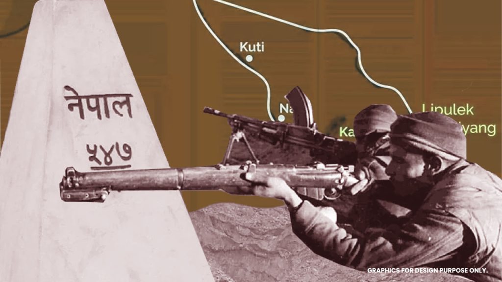
But after 1856 A.D., as to create confusion regarding maps published began to have some intentional differences. In the map published by General of India in 1856 A.D. instead of a tri-junction point at Limpiyadhura by the following Kali river as the boundary, a small river flowing from Lipu Lek was made the boundary and Lipu lake was made the tri-junction. Lipu lake is a very important region for trade. This pass is much easier than other passes for Tibet. Every year from 1 June to 31st October, trade between India and China is being conducted through Lipu lek pass.
History of Kalapani encroachment
Kalapani was encroached from 1962 by India using its military.
In 1952, Nepal gave permission to temporarily place Indian Armies in its Northern boundary foreseeing the dangers from the Chinese side. In the year of 1962, India made a bunker in Kalapani and placed its camp there, as the China-India war broke out. At that time, the there were 18 Indian camps including Kalapani, inside the Nepalese borders. After the war, when Nepal asked the Indian side 0to remove its armies from all Nepalese regions, India removed them from all the places except in Kalapani. And even till now, Kalapani is under the Indian Military’s control. One step forward of the military encroachment, India took a political step in encroachment as it added Kalapani to its border on the new map published by Survey of India on November 2, 2019.
Why is Kalapani important for India? Why did it encroach it?
The main region for encroachment of Kalapani area by India is the strategic importance of Kalapani.
The armies with height have a significant advantage when fighting in a mountainous area. The armies below can be readily attacked by them. The troops above can easily find covers while the troops below lie venerable have to face great difficulty of ascending the height to launch the attacks. That similar sort of benefit exists for Kalapani. Because of this geographical structure of the area, China made no attempts to attack Kalapani during the Indo-Chinese War in 1962 AD. When India realized this strategic importance of Kalapani area, it wanted to remain there.